|
The Earth Systems Ecology Lab (www.hurteaulab.org) at the University of New Mexico is recruiting a PhD student for a tree regeneration project. Post-fire reforestation in the southwestern US typically has low survival rates because of heat and drought, a challenge that is likely to worsen with ongoing climate change. We have been working to develop predictive models to increase the probability of planted seedling survival. If you are interested in post-fire vegetation dynamics, reforestation, microclimate, or some combination therein, consider applying to join us. Chris Marsh and I have just initiated a USDA funded project that includes; planting 10,000 seedlings , deploying 400 microclimate sensors and collecting conventional and thermal imagery using drones, aiming to better characterize the thermal environment which affects seedling survival and growth.
If you are interested in undertaking research to help post-fire reforestation efforts, this is the project for you. Student support will include some combination of teaching and research assistantships, including summer salary support and research project support. If the adventure of obtaining your PhD is going to be a good and rewarding one, it is important that you find the right advisor for you. I wrote this so potential students can get a sense of my approach. If you read that and are intrigued, I may be a good fit for you. If you read it and are put off, I’m not going to be a good fit for you. If after reading the potential students page you are still interested, send me ([email protected]) or Chris Marsh ([email protected]) a single pdf with your CV, one-page statement of research interests, and your unofficial transcripts. UNM Biology doesn’t require GREs and the only thing I think they measure is how well you did on your GREs, so I don’t require them. We use this unofficial application process so you don’t have to spend $60 to figure out if we think you are a good fit for the position. I didn’t have an extra $60 when I was applying to grad school and I figure you probably don’t either. We will begin reviewing application materials on 1 October. We will ensure that any finalists have the opportunity to speak with everyone in the lab. We are a hardworking and supportive group that likes to work on research projects that will hopefully leave the world in a little better shape than before we started.
0 Comments
We are recruiting a postdoctoral researcher with a strong background in spatial data analysis and programming to contribute to a project on quantifying forest carbon risk across the western US. The objectives of this position include developing spatial layers of forest condition and disturbance and climate risk at the watershed scale using a process that assimilates multiple data sources at varying grain sizes and extents. The position will involve engagement with conservation organizations and collaboration with project members in the Earth Systems Ecology Lab.
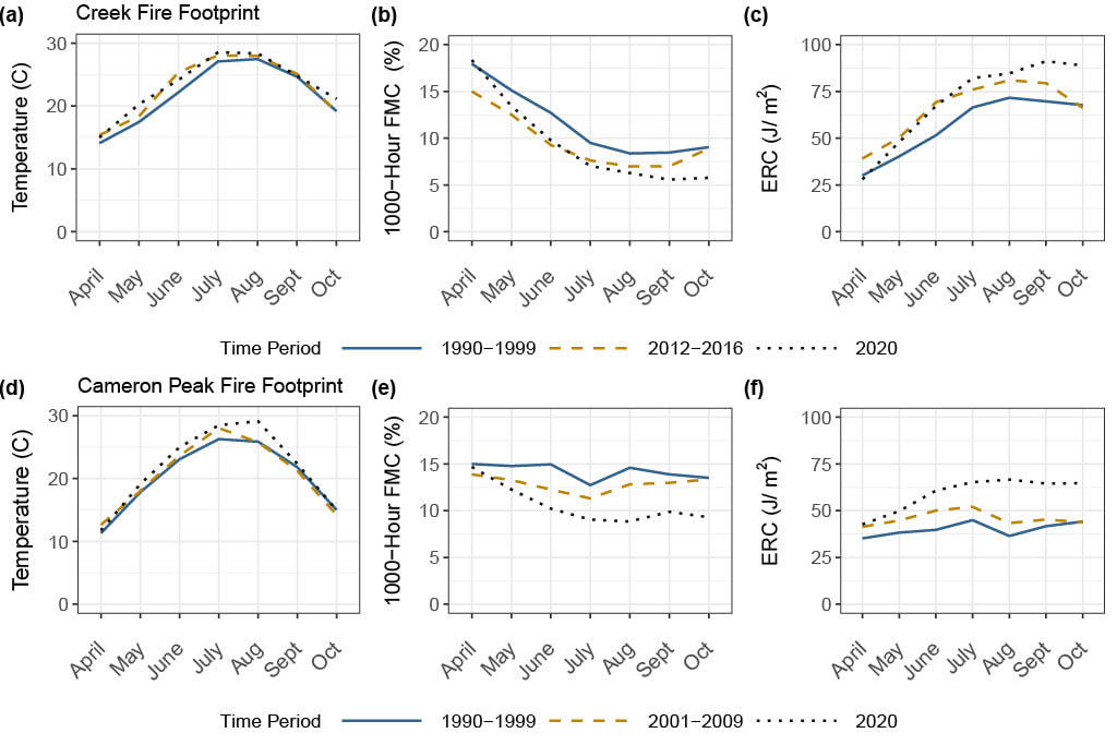
This is a 24 month position, beginning fall 2022. Salary is $55,000 per year, plus benefits. Required qualifications include a PhD in ecology, ecosystem science, earth/environmental sciences, or statistics, and programming experience with R. Familiarity or expertise with satellite-based remote sensing is desirable. Applicants should submit a cover letter detailing research interests and goals, a complete CV, and names and contact information for three references to Matthew Hurteau ([email protected]). Review of applications will begin on 1 SEPT 2022. The University of New Mexico is committed to hiring and retaining a diverse workforce. We are an Equal Opportunity Employer, making decisions without regard to race, color, religion, sex, sexual orientation, gender identity, national origin, age, veteran status, disability, or any other protected class. by Marissa GoodwinRising temperatures are drying out forests in the western US. As temperatures increase, so does the atmosphere’s demand for water, a relationship known as the vapor pressure deficit. Numerous studies have shown that as vapor pressure deficit increases with climate change, the amount of water stored in both live and dead vegetation decreases. In fire-prone forests, this means that the fuel loads in these systems are becoming drier making them more available to burn when wildfire occurs. This is because the amount of water stored in live and dead vegetation (known as fuel moisture content) controls the amount of time and energy needed to vaporize that fuel moisture before ignition can occur. As fuels dry out, they burn more readily, and as a result we have seen an exponential increase in the forest area burned in the western US. Climate change has increased drought frequency and severity as well as insect outbreaks which has resulted in widespread tree mortality. The substantial tree die-off from these mortality events increases the total amount of dead fuels available in the forest, which are inherently drier than live trees. Because fuel moisture content regulates the amount of heat energy that is released during wildfire, fires that occur where there is a surplus of dead fuels may release a significant amount of energy as heat. Consequently, the combined effect of rising temperatures and widespread tree die-off on fuel moisture content may in part be responsible for the unprecedented wildfire behavior we have seen in recent years. In our recent study, we assessed how the combined effects of tree mortality and rising temperatures increased fuel availability and potential heat energy release in the areas where two megafires occurred: the Creek Fire in the southern Sierra Nevada of California and the Cameron Peak fire in the Rocky Mountains of Colorado. Both fires occurred during the 2020 fire season and were preceded by widespread tree mortality. The Creek Fire was one of the largest in modern California history and burned in an area where the 2012-2016 drought and bark beetle outbreak resulted in widespread tree mortality. The Cameron Peak Fire, which was the largest in Colorado history, burned through forest with large numbers of bark beetle-killed trees. In our study, we used temperature and fuel moisture content data to calculate changes in fuel availability in these two forests over the past three decades. Additionally, we calculated how this influenced the amount of heat energy that could be released during these wildfires and how the transition of trees from live to dead fuels influenced potential energy release. We found that tree die-off in these two forests transitioned substantial amounts of biomass from live to dead fuel pools. This transition, coupled with reductions in fuel moisture content from rising temperatures, resulted in substantial increases in fuel availability and the amount energy available for release in the areas where these two fires occurred. For example, in the footprint of the Cameron Peak fire, we estimated that higher temperatures coupled with dead fuel loading from beetle mortality resulted in a 55% increase in fuel availability and a two-fold increase in potential energy release. Because heat energy release drives fuel ignition and wildfire spread, our results suggests that the combined effects of tree mortality and rising temperatures likely play a role in the unprecedented fire behavior that has characterized modern wildfires. Fires that occur where there is surplus of dry, dead fuels may be perpetuated not only by available fuels, but also by the substantial amounts of energy they release.
|
Details
Archives
October 2023
Categories
All
|


 RSS Feed